Unless there is a snap Assembly or Westminster election called within the next 18 months, this month’s Assembly Election will be the last Northern Ireland election to be fought under the existing 18 constituency map.
Under the Parliamentary Voting System and Constituencies Act of 2011, the number of Westminster constituencies will fall from 650 to 600, and as a result of this there will be a reduction in the number of Northern Ireland constituencies by one, from 18 to 17. An interactive map of the proposed new constituencies, with the ability to superimpose the existing constituency map, can be viewed on the spatialni.gov.uk website.
I built a model to try and work out what the results of the 2017 Assembly Election would have been if they had have been fought on the new boundaries. This is obviously a (very) inexact science. I apportioned the number of Sinn Féin and SDLP votes to each 2011 Census Ward by the estimated number of Catholic adults in each ward.
I extrapolated that there were 670,224 Catholic adults in Northern Ireland on election day, compared with 605,001 in 2011. Unionist parties and the Alliance Party have had their vote apportioned to wards on the basis of the non-Catholic vote in each ward. I appreciate that distributing Alliance votes in this way is dumb, and that treating the vote as nothing more than a sectarian headcount is depressing, but I couldn’t think of a better methodology.
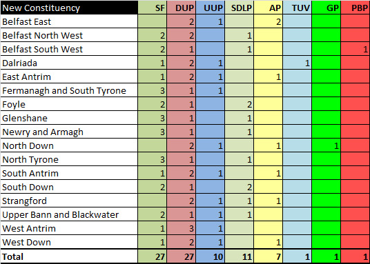
Using this method, I estimated that the number of first preference votes for each party under the new 17 constituencies would have been as follows.

In a Westminster election, the DUP would expect to win eight of the new seats; West Antrim, Dalriada, Strangford, North Down, West Down, East Antrim, South Antrim and Belfast East. Unless they are assisted by a Unionist pact, the UUP don’t appear to be close enough to the DUP to win any of these.
Nationalists will win easily in Glenshane, North Tyrone, Newry and Armagh, South Down, Foyle and Belfast South West. Under present form Sinn Féin would win all of these, but the fact that Foyle and South Down have relatively unchanged boundaries might help the SDLP to cling on at a Westminster election.
The remaining three seats of Fermanagh and South Tyrone, Belfast North West, and Upper Bann and Blackwater are all Nationalist majority constituencies that could conceivably be won by a Unionist unity candidate. However, Sinn Féin would be the narrow favourite to win all of these, even against a Unionist unity candidate.
A Westminster election would expect to see the DUP winning eight seats and Nationalists winning nine, however with a Unionist pact and a reversion to the sort of turnout differential seen in 2016, it is possible that Unionists could win as many as eleven seats.
In terms of an Assembly election, the number of estimated quotas for each party in each constituency is as follows.

In terms of seat estimates, I guessed the following.
Of course, much of the final seat projection is complete guesswork, and there are a number of very marginal seats. For example, the fifth seat in Belfast South West would be expected to be a close contest between Sinn Féin, Alliance, and People Before Profit. Also, the reduction in the number of seats makes it harder win three of the five seats, and the DUP could struggle to win three seats in any constituency, unless of course there is some sort of merger with the UUP.
The redrawing of Northern Ireland’s electoral map is unlikely to produce much in the way of immediate benefits to either Nationalist or Unionist parties. However, the reduction in seats from 90 to 85 could throw up more marginal contests than exist under the current boundaries. There are likely to be some very close electoral calls over the coming years.
A qualified accountant and data analyst, interested in politics, economics and data. Twitter: @peterdonaghy
Glenshane, a constituency split by a mountian, police districts, esucation authorities and health trusts, gerrymandering at its best.
Well done mate, thanks for this and a big big thanks for making me smile 😉
I love how these eejits teleport Dundonald between North Down and Lisburn depending on election when it is really part of Belfast. Geography certainly does not get in the way of a complete gerrymander.
Come on now and be fair. I agree that Dundonald most likely should be part of an East Belfast Constituency maybe? But to cry ‘gerymander’ is nonsense. They have to draw lines somewhere?
If you can get hold of the ballot box tallies collected by one of the parties, you can make a more accurate estimate of first preferences on the new boundaries.
Nevertheless the analysis shows SF & DUP equal on seats and nationalist and unionist generally equal on seats. If there was a few years to the election then nationalists or the centrists might sneak an extra one at the expense of the unionists.
If the SDLP and Alliance can make more of their opposition to Brexit they might do better, but it is hard to think of Alliance taking a strong position.
Yes they do, but they should in a proper in a geographical manner. I dont see any other constituency with a narrow appendage like East Belfast. Practically every main town in the east has its electoral boundary at its edge, pure gerrymandering and as Hugh says Glenshane is just a joke. The size differentials in constituencies are also hilarious more like casting a net.
Fascinating stuff. I actually tried to find AE17 first preferences by ward but couldn’t find any. Can someone tell me where I can find ward by ward voting results (first prefs) online? Thanks
Population size is the main determinant of electoral constituencies, not geographical or land area. Each constituency (with exceptions for The Western Isles) must have a population within limits determined by Parliament. In addition, the constituency boundaries must follow existing ward boundaries. So – if you don’t like the new boundaries you can either change the wards or move the populations.
Why then is the Lagan used as the only defacto geographical line on the whole map. If Geography is not a factor which it is not on most of the Map we should remove the Lagan from play as a demarcation line. It is obvious its a gerrymander nobody looking at that map could claim differnetly. Four viable constituencies in Lagan Valley, North Antrim and Upper Bann and Mid Ulster are destroyed to accomodate this nonsense. Why was the axis of Dungannon and Cookstown not considered for the basis of a constituency? Answer because its a Gerrymander.
Grow up. Its done by an independent commission and the breaks have to fall somewhere
Dundonald is niether in Lisburn nor North Down. The experts just followed the path of least political resistance. East Belfast is now shaped like it was put in a vice and the Sperrins completely ignored. Yeah the breaks have fall somewhere. Belfast should have a central constituency if it is ever properly to develop like a normal city. Whether that centre is nationalist or Unionist i dont rightly care, and the constiuencies should simply work outwards from there.
Sorry, Peter, but these calculations must be wrong. Take a look at the quotas.
Given that the new constituencies have similar size electorates to each other the size of the quotas should differ from each other by little more than the difference in actual turnout 12 days ago.
Yet we see Belfast East (substantially the same constituency as today’s Belfast East which had a turnout of 63%) having a quota of 9,285. On the other hand Foyle (substantially the same as today’s Foyle which had a slightly higher turnout of 65%) is allocated a quota of only 6,948.
As another example East Antrim is out of relationship with both Belfast East and Foyle.
IMO the margin of uncertainty in using census figures to try and determine first preference votes for political parties and the transfer pattern through to the fifth seat is simple too great to be valid.
A better model, still with significant uncertainties, would be to take the 2014 Council election results and apply the swing since then to each party’s first preference vote. Then allocate each District Electoral Area (or part of a DEA) to its new constituency. Total the first preference votes and apply the known transfer patterns to provide a notional result. Even then the result might be little better than simply guessing.
I suggest you take the matter up with the boundaries commission
I wish you’d be more careful with your terminology. Gerrymandering means drawing boundaries to favour a particular group. In this case, it’s hard to see which group is favoured. Badly drawn boundaries are not the same as a gerrymander and the necessity to have all of them within 5% of the average will inevitably mean that geographic features have to be disregarded.
They’re not available.
Then how did the article above get written without such data?
Only the parties will have this information from their tallies at the count and they will not share it as itis vital to their campaigning in future elections. The bigger the party the more accurate the tallies.
He’s explained his methodology above. He’s used local election figures.
All the parameters used to determine the new constituency boundaries are contained in this document. All you need now is a map, 4 different-coloured markers, a list of eligible voters in every ward and some time. We look forward to viewing your improved result.
Have you a better suggestion for 17 seats? That even out the numbers across each constituency? The numbers are available, I gave it a go, and its really difficult to get contiguous seats across North Down/East Belfast, and south Derry.
Peter your work is generally good but you need to map these onto local government voting patterns. No hope of SF outpolling the SDLP in West Down. SDLP vote in Upper Bann is concentrated in Banbridge and SF in Lurgan/Portadown.
Interesting piece.
I think you underestimate the chances of a green seat in Belfast East. The Belfast South West seat will also have a sizeable Green and Alliance (3.5 -4K) vote transferring in from the parts of Balmoral and Botanic that move.
Just for reference, it is not guaranteed the next election will be under these boundaries. They could be rejected by the Commons (in which case the current boundaries will remain). I wouldn’t like to predict which way the relevant Commons vote will go.
For what it’s worth I think its going to fall. More than enough Conservatives have spoke out against this during the summer arguing there was no longer a need to reduce the HoC given Brexit, despite the fact 600 seats broadly favours them and would shred labour to pieces. The DUP sure as hell won’t be riding to the rescue either and the SNP are likely to be in foul form by the time it comes to a vote.
But who’s expense would that Green come at? Can’t see it being the DUP or Alliance with them parking the bus on 2. Would likely have to be UUP?
For what it’s worth given the SDLP are gone in West Belfast and PBP being caught out over Brexit I think Bailey could really take a shot at it given it’s the home of the larger chunk of South Belfast. I don’t have access to tally figures for the West but I’ve a hunch Carroll is stronger in the Lower Falls which goes NW.
Jimmy
Have a go with this – http://boundaryassistant.org/
It is easy to suggest a Central constituency, but what does it include?
Regional Quota – 73139
Minimum – 69401
Maximum – 78507
What you suggest for example, if I remove all the North Belfast Wards as is, and add some from South Belfast to East to create a South East, leaves a weird Central Constituency that stretches from city centre all the way to west belfast and lisburn.
At the same time North Down is still well short, where are you getting them from? Strangford? Do you take some of Ards, or take the Ards peninsular?
Duncairn
New Lodge
Sydenham
Ballymacarret
Central
Falls
Shankill
Waterworks
Ormeau
Woodstock
Blackstaff
Windsor
Stranmillis
Malone
Beersbridge
Connswater
Bloomfield
Fortwilliam
Innisfayle
Ravenhill
70934, looks sensible on a map and would be the first step to bring Belfast into the 21st century.
UK Government decision to reduce the number of seats – this blog is on the basis of this happening.
And if you are wrong then you will have no excuse
For being ill prepared if it does
Ok Gopher – seat looks good, but its bringing together parts of the city that have no real connection.
Regardless, what happened to your North Belfast seat? Looks like its out to Carrick or Antrim? Its just lost 5 wards, take nearly 20k off its total, bringing it down to 70k – where you getting the rest from?
Similarly, south east, with all the south and east bits there is just under left unless you extend into west belfast or up into North Down?
Problem with North Down is, Bangor and Ards combined with the areas inbetween are too big for one seat, so whats going to happen there – Holywood in your South East West Belfast seat, Bangor and half of Ards together?
I’m sure it will make little difference to you, merely pointing out that your proposal is difficult to make work.
Belfast needs to develop as a social, cultural, and economic unit not secterian one. A central Belfast constituency is a step in the right direction. You have to get people with disposable income living in Belfast City centre. I added Rosetta to it.
My Map looks just great. South Antrim goes, North Down takes in the Ards Pen except Portaferry which goes to South Down. East Belfast or “Inler” as its now known includes Ards, Strangford becomes East Down. Mid Ulster and West Tyrone stick to geography and it was all done in under an hour.
North Belfast was a breeze
From what I could see, the one constituency eliminated was in Belfast where only East Belfast remained intact and the existing North Belfast, West Belfast and South Belfast were replaced with two new constituencies: Northwest Belfast and Southwest Belfast. The other constituencies seem to have at most changed their names in a few instances.
Indeed he has – 3 Belfast seats, with your central one stretching from the fortwilliam roundabout to falls park, then up to Rosetta, and over to Sydenham.
The south east “Belfast” seat takes in Ards and comber, as well as ballyhackamore, dundonald, four winds, drumbo, and Malone.
The north Belfast seat combines ardoyne with Carrick and crumlin, while outer west Belfast is in with Lisburn.
Plenty of substance for sure, but 4 very unconnected constituencies.
It looks messy, but definitely reducing the number of nationalist seats. Taking portaferry out of north down and the Ards peninsula will guarantee no nationalist mla, clever.
I am not sure having this central constituency would give Belfast a centre, fortwilliam and falls park and Rosetta and Sydenham appear to me to be unwieldy.
What’s left of Belfast is a mess that stretches way beyond Belfast too.
North, West and East Belfast are very distinctive areas for historical and geographical reasons, has nothing to do with constituency.
North Belfast does not take in Carrick in my Map. Nope all the constituencies take in major Roads and Motorways as their Axis on my map. The main principle is to bring economic life in Belfast into one constituency and largely remove the brakes to that. Private housing and Private rental housing is freed from the constraint of being outnumbered by those dwelling in social housing. If you want Belfast to develop at a snails pace keeping its economy tied to social housing through constituecy boundaries like in the new map, that is one is one way to go about it.
Sorry, how will creating this constituency have an impact on economic life in Belfast?
And not sure if you know the areas but this new seat takes in massive amounts of social housing from all parts of Belfast, from waterworks to black staff to Ravenhill to Sydenham.
Also curious how your North Belfast works – where are the additional 20k coming from?
Lots to play for over those coming years. Council 2019 will give us a much better figure. I think it would be primarily the UUP seat at risk but its all conjecture this far out.
As for South West it could indeed be an interesting one. PBP’s star may be on the wane and likely that local elections in 2019 will be right in the face of Brexit which will not suit them at all.
Not if the incumbent large parties can have their secret sponsors fund their campaigns:
https://theconversation.com/q-a-how-the-conservatives-landed-a-70-000-fine-after-an-expenses-scandal-74711
These pitiful fines can be seen as the cost of doing their dirty business.
The problem is divinging the voting population into even chunks.
I can’t image having like a City Centre constituency then a City Suburbs one that encircles both motorways.
Maybe merging a bit of the East into the South, a bit of the South into the West, a bit of the West into the North and a bit of the North into the East challenges the tribalism to an extent.
Future Belfast East contains a large part of South Belfast. It will probably be a bigger constituency than Foyle.